Risk Preparedness and Resilience Planning for Emergency Evacuations of Wrangell-St. Elias National Park
Programmatic Clearance Process for NPS-Sponsored Public Surveys
WRST_Resident Survey 12-3-24
Risk Preparedness and Resilience Planning for Emergency Evacuations of Wrangell-St. Elias National Park
OMB: 1024-0224
OMB#: 1024-0224
Expiration Date: XX/XX/XXXX
WRANGELL-ST. ELIAS RISK
PREPAREDNESS AND RESILIENCE PLANNING FOR EMERGENCY
EVACUATIONS
RESIDENT SURVEY
PAPERWORK REDUCTION and PRIVACY ACT STATEMENT: The Paperwork Reduction Act requires us to tell you why we are collecting this information, how we will use it, and whether or not you have to respond. We are authorized by the National Park Service Protection Interpretation and research in System (54 USC §100702) to collect this information. The routine uses of this information will be for the benefit of NPS Managers and Planning staff managers to understand behaviors and perceptions salient to emergency planning and evacuation along the McCarthy Road portion of Wrangell-St. Elias National Park and Preserve. The data collected will be summarized to determine evacuation intention and model emergency evacuation behavior along the McCarthy Road portion of Wrangell-St. Elias National Park and Preserve. Your responses to this collection are completely voluntary and will remain anonymous. You can end the process at any time and will not be penalized in any way for choosing to do so. All contact information collected for the purpose of the follow-up survey will be destroyed at the end of the collection period and no personal identifiable records will be maintained or stored for any purposes. Data collected will only be reported in aggregates and no individually identifiable responses will be reported. A Federal agency may not conduct or sponsor, and you are not required to respond to, a collection of information unless it displays a currently valid OMB Control Number.
BURDEN ESTIMATE STATEMENT: Public reporting burden for this collection is estimated to average 14 minutes per response. You may send comments concerning the burden estimates or any aspect of this information collection to: Jonathan Schafer, jonathan_shafer@nps.gov, (907) 379-0389.
Section Description: The focus of this study is to understand behaviors and perceptions salient to emergency planning and evacuation along the McCarthy, Kennicott, and Nizina Road Corridors of Wrangell-St. Elias National Park and Preserve among visitors, residents, and property owners. The study area is loosely defined as a stretch of land along the McCarthy Road and beyond from Chitina, AK to Kennicott and the Nizina River, which will be referred to as the “McCarthy Road Corridor.” The data will be used to inform emergency response management, including investment in preventive infrastructure, the development of tools and models to make emergency evacuation safer, and other future management decisions about this area. Your participation in the study is voluntary, and your answers will remain anonymous. Our results will be summarized so that the answers you provide cannot be associated with you or anyone in your group or household. The survey will take approximately 15 minutes to complete. |
TOPIC AREA 1: EMP2 (Variation: Specified for common professional roles within the specific community. This question will determine the distribution of respondents’ professional roles in the community, which may help cluster samples based on shared attributes that can inform how they will behave during an emergency evacuation) |
Which of the following categories would indicate your current professional role in the McCarthy Road Corridor? (Select all that apply)
Guide
Business owner
Hospitality or visitor services (i.e., hotel, shuttle, food service)
Retiree
Tribal organization employee
Federal employee
State employee
Nonprofit employee
Caretaker
Researcher or scientist
Emergency services
Other: ____
I have no professional role in the McCarthy Road Corridor
TOPIC AREA 4: TRANSMODE2 (Variation: Modified question to add management site and “most recently” for clarification among the sample population. Irrelevant response options removed. Added popular forms of transportation within the community) |
By what means did you most recently enter the McCarthy Road Corridor? (Check one).
Personal Highway Vehicle (car, truck, SUV)
RV (including motorized or trailer)
Motorcycle
All-Terrain Vehicle or Off-Highway Vehicle
Walking/Hiking
Bicycle
Electric Bicycle
Shuttle or bus
Watercraft
Aircraft
Other (please specify):________________
TOPIC AREA 2: ITIN7 (Variation: Modified question to remove questions on planned transportation methods and to mirror response options from transmode 2 for clarity and consistency. Excludes “visit” because sample population is residents.) |
Which mode(s) of personal transportation do you use within the McCarthy Road Corridor? (Check all that apply.)
Personal Highway Vehicle (car, truck, SUV)
RV (including motorized or trailer)
Motorcycle
All-Terrain Vehicle or Off-Highway Vehicle
Walking/Hiking
Bicycle
Electric Bicycle
Shuttle or bus
Watercraft
Aircraft
Other (please specify):________________
TOPIC AREA 1: RES (New question: This question will be used to filter out questions that are not relevant to temporary residents.) |
Which one of the following best describes the property where you live within the McCarthy Road Corridor?
A private residence that I or my family owns
Temporary residence that my employer owns
Temporary residence that is owned by someone other than my employer
Other: ______
TOPIC AREA 1: Res 1 (Variation: Modified to clarify residence attributes of the community [i.e., some people consider the road their primary residence but may travel]). |
Which one of the following best describes your residency within the McCarthy Road Corridor? (Check one).
Permanent resident (people with primary residence in the area, even if they are away for travel for a few months each year)
Seasonal resident (returning to a property you own annually for 1-6 months)
Not a resident
TOPIC AREA 3: CVIS2 (Variation: This question will measure the length of time participants have resided within the study area, which has been shown to influence evacuation ability and intention.) |
How many years have you lived in the McCarthy Road Corridor?
_______ years
TOPIC AREA 1: RES (New Question: This question will allow for a better understanding of the spatial distribution of respondents’ residence because zip code isn’t refined enough to reliable measure residence in along the McCarthy Road Corridor) |
Which one of the following best describes the location where you live within the McCarthy Road Corridor? (Check one.)
Chitina
Strelna
Chokosna
Long Lake
Fireweed
West McCarthy
McCarthy
Kennicott
Nizina
Other (Please specify) _________
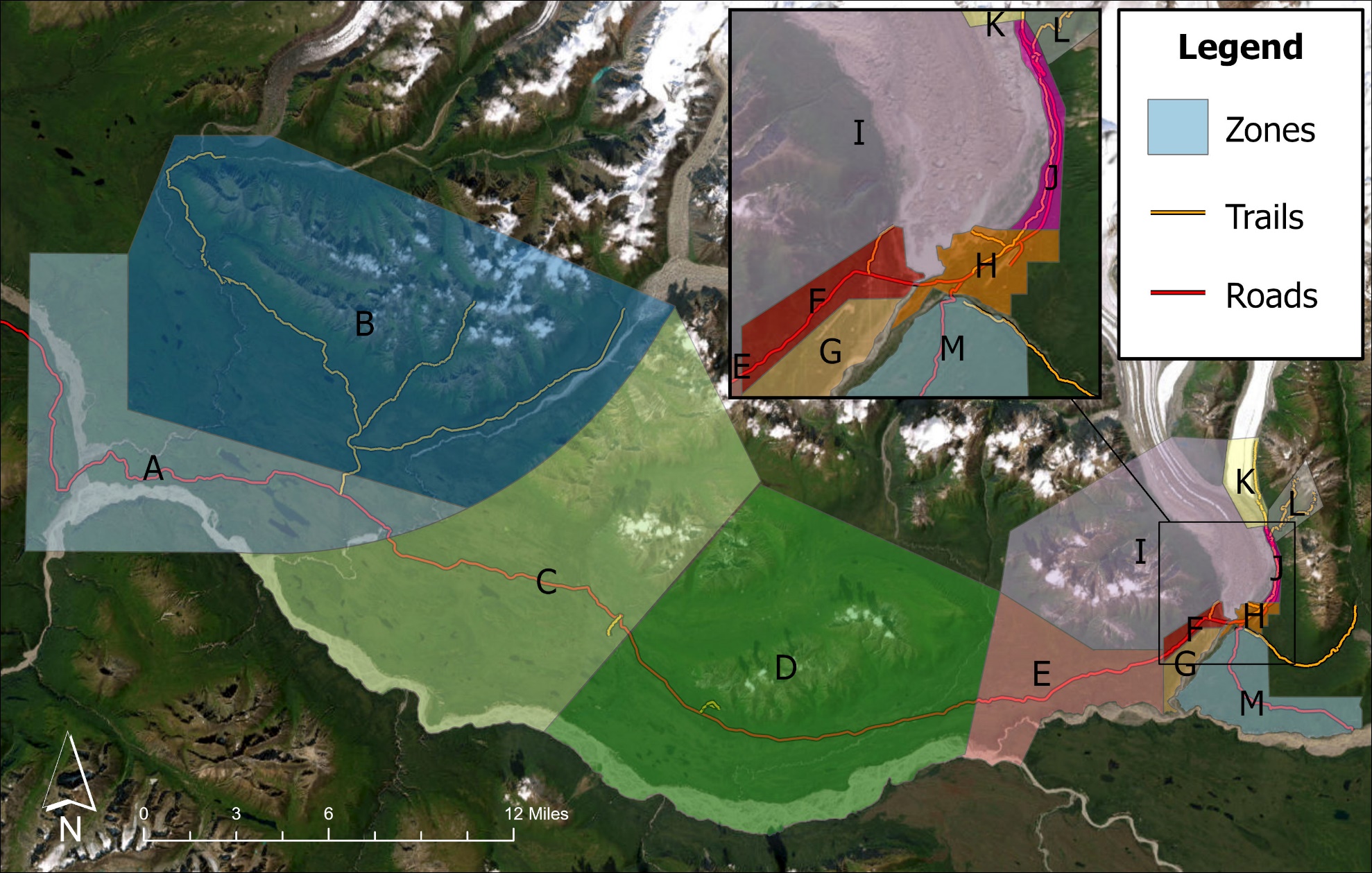
TOPIC AREA 3: DEST6 (Variation: Modified question to incorporate specific management area of the park and added specific park locations; see map at the end of the survey) |
For today only, please select all the locations that you visited in the McCarthy Road Corridor. (Check all that apply. Use the map on the next page to help you identify the locations you visited.)
Zone A – Chitina to Kuskulana Bridge
Zone B – Nugget Creek Access Trail North
Zone C – Kuskulana Bridge to Gilahina Trestle
Zone D – Gillahina Trestle to Long Lake
Zone E – Long Lake to South Fireweed
Zone F – West McCarthy (Road & Mixed Commercial)
Zone G – West McCarthy (Residential)
Zone H – McCarthy
Zone I – Fireweed Backcountry & Kennicott Glacier
Zone J – Kennicott to McCarthy Airport
Zone K – Jumbo Creek & Root Glacier
Zone L – Mine Trails
Zone M – McCarthy Creek to Nizina
Other ______
TOPIC AREA 7: KNOW10 (Variation: Modified question to add management priority and increased number of response options retaining the same range to improve psychometric properties) |
How knowledgeable are you on the topic of emergency evacuation planning?
Not at all Knowledgeable |
Slightly Knowledgeable |
Somewhat Knowledgeable |
Very Knowledgeable |
Extremely Knowledgeable |
£ |
£ |
£ |
£ |
£ |
TOPIC AREA 7: MGMTOPT14 (Variation: Added items relevant to area-specific issues and management priority and increased number of response options retaining the same range to improve psychometric properties) |
How much of a problem do you think the following issues are in the McCarthy Road Corridor?
|
|
Not a Problem |
Small Problem |
Moderate Problem |
Significant Problem |
Big Problem |
Don’t Know/ No Opinion |
|
Wildfires |
1 |
2 |
3 |
4 |
5 |
DK |
|
Building structural fires |
1 |
2 |
3 |
4 |
5 |
DK |
|
Flooding |
1 |
2 |
3 |
4 |
5 |
DK |
|
Mudslides |
1 |
2 |
3 |
4 |
5 |
DK |
|
Road or bridge washouts |
1 |
2 |
3 |
4 |
5 |
DK |
|
Medical services |
1 |
2 |
3 |
4 |
5 |
DK |
|
Disaster response time |
1 |
2 |
3 |
4 |
5 |
DK |
Disaster response management |
1 |
2 |
3 |
4 |
5 |
DK |
|
TOPIC AREA 7: TRUST1 |
Do you trust Wrangell-St. Elias National Park and Preserve to manage the following?
|
YES |
NO |
DON’T KNOW |
Safety |
£ |
£ |
£ |
Building structural fires |
£ |
£ |
£ |
Motorized vehicle use |
£ |
£ |
£ |
Wildfires |
£ |
£ |
£ |
Coordinate disaster response with the State of Alaska |
£ |
£ |
£ |
Coordinate disaster response with volunteer emergency services |
£ |
£ |
£ |
Coordinating emergency medical services during a disaster |
£ |
£ |
TOPIC AREA 7: TRUST3 (Variation: Increased number of response options to improve psychometric properties) |
Over time, how has your level of trust in the Wrangell-St. Elias National Park and Preserve staff changed? (Check one.)
Worsened a lot |
Worsened |
Has Not Changed |
Improved |
Improved a lot |
Don’t know |
£ |
£ |
£ |
£ |
£ |
£ |
TOPIC AREA 7: PREF2 Text will auto-fill based on respondents answers to #7, so that place-attachment is based on the community respondents reside in.) |
Please indicate your level of agreement or disagreement with each of the statements. (Check one.)
|
Strongly Disagree |
Disagree |
Neutral |
Agree |
Strongly Agree |
Don’t know |
[Answer from #7] means a lot to me. |
£ |
£ |
£ |
£ |
£ |
£ |
I am very attached to [Answer from #7]. |
£ |
£ |
£ |
£ |
£ |
£ |
I feel no commitment to [Answer from#7]. |
£ |
£ |
£ |
£ |
£ |
£ |
No other place can compare to [Answer from #7] |
£ |
£ |
£ |
£ |
£ |
£ |
I feel that I can really be myself at [Answer from #7] |
£ |
£ |
£ |
£ |
£ |
£ |
Few people know [Answer from #7] like I do. |
£ |
£ |
£ |
£ |
£ |
£ |
I feel a sense of pride in my heritage when I am at [Answer from #7] |
£ |
£ |
£ |
£ |
£ |
£ |
[Answer from #7] is a special place for my family. |
£ |
£ |
£ |
£ |
£ |
£ |
TOPIC AREA 11: SAFPREP (New Question: This question will allow understanding of the amount of time it will take respondents to perform basic tasks common during an emergency evacuation) |
If your household is together when you receive a mandatory evacuation order, how many minutes, would it take to…
|
Would not do it |
1-15 |
16-30 |
31-45 |
46-60 |
61 or
more |
pack the items you will need to take with you? |
£ |
£ |
£ |
£ |
£ |
£ |
protect your property from wildfire damage? |
£ |
£ |
£ |
£ |
£ |
£ |
shut off utilities, secure your home, and leave? |
£ |
£ |
£ |
£ |
£ |
£ |
pick up other people who are evacuating with you? |
£ |
£ |
£ |
£ |
£ |
£ |
stop to get supplies anywhere other than your home? |
£ |
£ |
£ |
£ |
£ |
£ |
TOPIC AREA 6: USETECH4 |
Are you able to receive internet/WiFi/cellular service while at your residence in the McCarthy Road Corridor?
Yes
No
TOPIC AREA 11: PERSAFE 12 (Variation: Minor change to reflect that the sampling population is residential and more likely to keep items at home or in a personal vehicle) |
Select the items you are currently carrying or keep readily available in your household or vehicle? (Check all that apply.)
Communication Device (smart phone, radio, etc.)
Paper Map
Compass
Electronic Map (e.g. Google maps, Apple maps, etc.)
GPS Device
Warm Clothing (In addition to what you’re wearing)
Extra Food
Extra Water
Light Source (A headlamp or flashlight)
Fire starters (Matches or Lighter)
TOPIC AREA 11: SAFPREP1 (Variation: Minor change to reflect that the sampling population is residential. Removed open response for “No” asking why they didn’t leave travel plans.) |
Do you have a trusted person who knows how to help you in case of an emergency?
TOPIC AREA 11: HAZARDEXP (New Question: This question will allow understanding the rates of prior natural hazard experience among respondents , which has been found to influence evacuation behavior.) |
Have you ever felt that your life safety was at risk from a natural hazard (e.g., wildfire, flood) at any point during your life?
YES
NO
→ If YES, what type of natural hazard? (Check all that apply.)
Fire
Flood
Hurricane/Tsunami
Heatwave
Earthquake
Other: _______
TOPIC AREA 11: SAW (New Question: This question will help management understand participation in opt-in communication systems among sample populations.) |
Have you enrolled in any mass notification systems (e.g., EverBridge) that communicate disaster information for the McCarthy Road Corridor?
YES
NO
TOPIC AREA 11: SAFEPREP(New Question: This question will allow understanding of the overall preparedness of the gateway community members in the McCarthy Road Corridor.) |
In case an immediate threat to your safety in the McCarthy Road Corridor requires you to evacuate, have you… (Check all that apply.)
Identified reliable evacuation transportation methods (i.e., your own or other people’s vehicles)?
Identified a destination community where you will evacuate outside the McCarthy Road Corridor?
Planned accommodations where you can stay during refuge?
Identified people outside of the corridor to contact with updates on your safety
Discussed where to reunite with your household if you are separated?
Discussed emergency evacuation plans with your household?
Written an emergency plan for your household?
None of the above
TOPIC AREA 11: SAFEPREP(New Question: This question will allow understanding how information will spread peer-to-peer among the sample population) |
If you receive an official evacuation warning, would you relay it to peers (friends, relatives, or neighbors)?
NO
YES
→If YES, how many? _______
→If YES how would you relay the evacuation warning to them? (Check all that apply.)
Face-to-face
Phone call
Email
Text message or messaging applications
Social media
Other_____
TOPIC AREA 11: SAFEPREP(New Question: This question will measure the mitigation efforts of properties in gateway communities along the McCarthy Road Corridor that may influence the spread of fire and life-safety of gateway community members – skip if PropOwn is not answered with “A private residence that I or my family owns”) |
For all my personal properties inside the McCarthy Road Corridor, within the last 10 years I have… (check all that apply):
removed trees less than 10 feet from my home.
removed branches of trees lower than 10 feet from the ground that are within 30 feet from my home.
removed branches of trees lower than 10 feet from the ground that are within 100 feet from my home.
cleared or maintained a 30 foot “green space” around my home.
spaced trees or shrubs at least 10 feet apart around my home.
removed trees between 30 feet and 100 feet high that are within 30 feet of my home.
TOPIC AREA 11: SAW (New Question: These questions will allow understanding of the worst-case fire scenario for the full sample and resident’s personal property and permit comparisons of responses between residents and tourists; interactive map area corresponds to zones in map at the end of the survey.) |
a. Place a pin at the location where you believe a summer wildfire ignition would pose the greatest risk to the life-safety of the general population of the McCarthy Road Corridor.
Use a map that will allow participants to place a pin on the disaster location in the McCarthy Road Corridor
b. Place a pin at the location in the McCarthy Road Corridor where you believe a summer wildfire ignition would pose the greatest risk to your personal life-safety.
Use a map that will allow participants to place a pin on the disaster location in the McCarthy Road Corridor, permitting respondents to respond with “Same as preceding question” to autofill location.
Section Description: For the next five questions, imagine the following scenario: A forest fire has flared up one mile upwind from your residence. You are at your residence, it is summertime, and there is daylight. Local officials believe that they will be unable to prevent the fire from spreading into nearby buildings, parking lots, and recreation areas. For the purposes of this section, the McCarthy Road Corridor encompasses the Nizina and Kennicott Road Corridors. |
TOPIC AREA 11: PERSAFE (New Question: This question will allow understanding the type of information that emergency managers will need to communicate and share to facilitate emergency evacuation) |
What information would you need to make a decision on whether or not to seek refuge during this scenario? (Check all that apply.)
Reports of the fire’s severity
Reports of the fire’s proximity
Seeing approaching flames
Experiencing heavy smoke that causes breathing difficulty
Experiencing loss of basic services (e.g., water, electric power, telecommunications)
Seeing other households evacuating
Distance to safe refuge locations
The services at safe refuge locations, such as their ability to accommodate pets or people with medical conditions
Other_________________________________________________________________________
None of these types of information
TOPIC AREA 3: INFOSOURCE7 (Variation: Specified wording to focus on info sources relevant to study purpose.) |
a. From which information sources would you prefer to receive information about a wildfire in the McCarthy Road Corridor? Please rank each option from most preferred (=1) to least preferred (=7).
National Park Service authorities
Federal authorities who are not affiliated with the National Park Service (e.g., FEMA)
State authorities (e.g., state troopers, firefighters)
Local emergency services (e.g., volunteer for the fire department, volunteer emergency medical services)
Employee of a visitor services company (e.g., hotel, bar, restaurant, or guiding company)
Friend or family members
Visitors or tourists
b. Through which information channels would you prefer to receive information about a wildfire in the McCarthy Road Corridor? Please rank each option from most preferred (=1) to least preferred (=10).
Phone call
Face-to-face
Sirens or alarms
Email
Text message or messaging applications
Emergency services phone alert
Social media
Environmental cues (e.g., smoke or flames)
Television or Radio
Social cues (e.g., people evacuati
TOPIC AREA 11: PERSAFE (New Question: This question will allow understanding of the evacuation intention of people within the McCarthy Road Corridor to improve management and outreach) |
Upon learning that a fire poses a significant threat to your life safety and property, which of the following actions would you take? (Check one.)
I will try to protect my property throughout the fire, taking shelter in the property if necessary.
I will do as much as possible to protect my property but leave if I think the fire has become too dangerous.
I will do as much as possible to protect my property but leave if I receive an evacuation order from authorities (e.g., state troopers, fire or other emergency services).
I will first protect my property and household but then leave to help with the emergency response.
I will immediately evacuate my property and help with the emergency response.
I will immediately evacuate to a safe refuge location as soon as I see that there is a dangerous fire without attempting to defend my property.
Other (please specify) _____________
TOPIC AREA 11: PERSAFE (New Question: This question will allow understanding where people plan to evacuate; interactive map area corresponds to zones in Supplement 1) |
If your household is together at your residence in the McCarthy Road Corridor, where would you seek temporary safe refuge from the fire if you had to leave your home?
Use a map that will allow participants to place a pin on their evacuation location in the McCarthy Road Corridor
TOPIC AREA 7: ECON10 |
How many people live in your current household in the McCarthy Road Corridor? _______ People
TOPIC AREA 1: Group 6 (Variation: Modified question to remove one conditional question and to more directly reflect sample population, which are households not visitors, and remove text) |
Does anyone in your household (including yourself) have any physical conditions that would make it difficult to receive, understand, or respond to an official evacuation warning?
NO
YES
→If YES, which physical condition are those? (Check all that apply.)
Hearing
Visual
Cognitive
Mobility
Other (Please specify)
TOPIC AREA 1: AGE 1 |
In what year were you born? ________
TOPIC AREA 1: EDUC 1 |
What is the highest level of formal education you have completed? (Select one.)
Some high school
High school graduate or GED
Some college, business or trade school
College, business or trade school graduate
Some graduate school
Master’s degree
Doctoral or professional degree
TOPIC AREA 1: Gend 1 |
What is your gender? Please select one.
Male
Female
Transgender, non-binary, or another gender
Prefer not to answer
TOPIC AREA 1: Group 1 |
Please select the choices below that best describe the members residing in your household. (Check all that apply.)
Individual
Family only
Friends/roommates only
Family plus friends
Preschoolers (less than 5 years old)
Children (6-11)
Teenagers (12-19)
Adults (20-64)
Seniors over 65
With pets
TOPIC AREA 9: ECON9 |
Which category best represents your annual household income? (Check one.)
Less than $25,000
$25,000 to $34,999
$35,000 to $49,999
$50,000 to $74,999
$75,000 to $99,999
$100,000 to $149,999
$150,000 to $199,999
$200,000 or more
TOPIC AREA 10: STAKE5 |
In your opinion, what do you think is the ideal role for the NPS to play in serving the public and surrounding communities in the context of emergency management?
__________________________________________________________________________________________________________________________________________________________________________
Supplement 1. Map of Zones Along McCarthy Road Corridor
| File Type | application/vnd.openxmlformats-officedocument.wordprocessingml.document |
| Author | Parkinson, Colby |
| File Modified | 0000-00-00 |
| File Created | 2025-05-18 |
© 2025 OMB.report | Privacy Policy